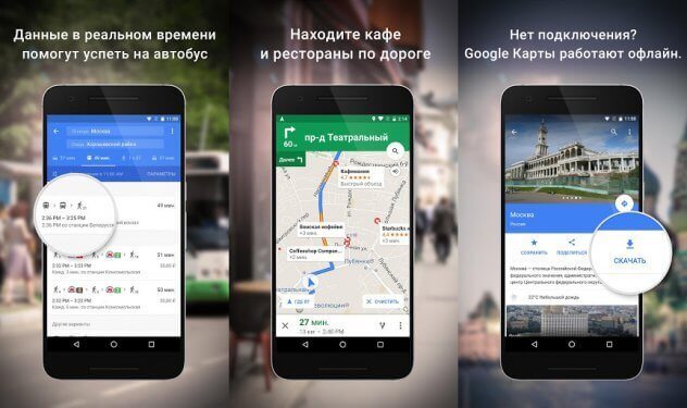
Google has spent a lot of time creating maps with a very high level of detail and additional features such as Street View and satellite imagery..
However, many of the functions demanded by users are poorly implemented in Google Maps, for example, full-fledged map loading for offline use and navigation with a lot of stops. Fortunately, other apps have these options, some of which are free.
Yandex.Navigator
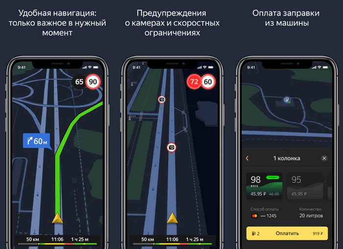
Trying to find a good roadmap for Russia or Ukraine can be difficult. Fortunately, Yandex has released its own navigator. He knows how to calculate the shortest route, shows traffic jams and accidents on the road. In order not to be distracted from driving, you can give voice commands. It is enough to say "Hey, Yandex" and tell the navigator what to do, for example, build a route from your current location to the nearest gas station. The top three routes will be shown to choose from, including the shortest..
You can download maps for offline use, enable 3D mode, receive important notifications, and use automatic zoom. The navigator can automatically switch between day and night mode, or you can set it manually. You can set your destination either with a simple touch or with the search function. And also using the search, you can find a variety of establishments: from ATMs to baths. If there is a toll road, it will be marked with a corresponding icon.
Available for Android and iPhone ..
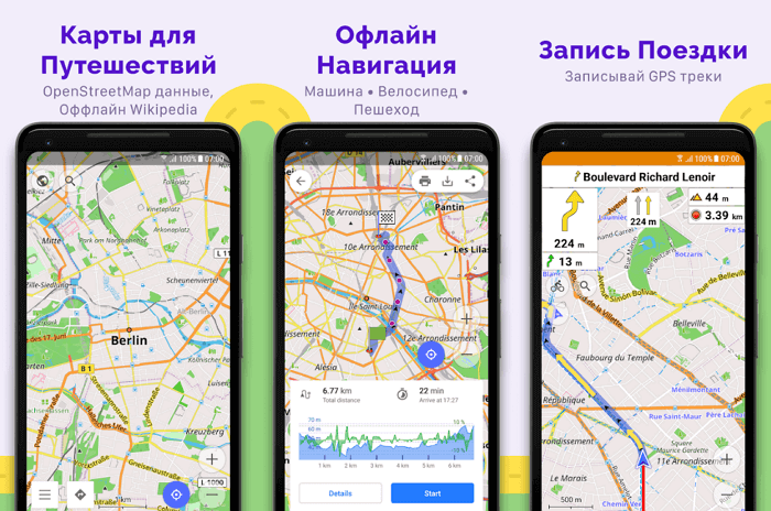
Maps.me
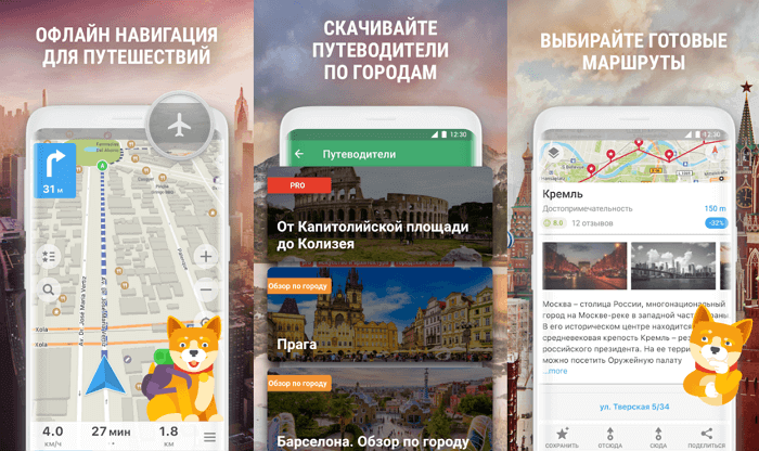
Maps.me provides offline map downloads, turn-by-turn navigation, map updates via OpenStreetMap. The functionality allows you to bookmark, perform offline searches, and receive up-to-date information on road traffic (when this information is available). The app is completely free, there are no paid updates. Advertisements are shown, but this does not cause any inconvenience.
An impressive database of places of interest: restaurants, shopping malls, free Wi-Fi zones, public toilets. Please note that you will not receive up-to-date traffic information in real time. The application is designed for offline navigation when there is no internet. You get full navigation support for 345 countries, as well as the ability to share your location data with your loved ones.
Offline mode available: full-featured search, voice navigation, laying of alternative routes, information about public transport . With internet access, you can even book a hotel room directly from the app.
When you start Maps.me for the first time, it will not ask you which region map you want to download. Instead, the download starts automatically for the current location. Navigation options include driving, motorbike or bicycle, public transport, taxi or walking.
Available for Android and iPhone .
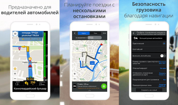
Sygic
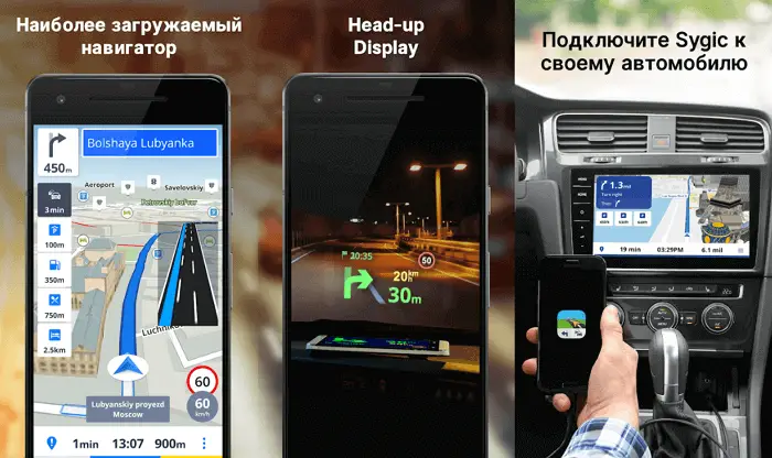
Sygic is a very popular navigation app. To date, it has been downloaded by over 50 million users. As with the other apps on our list, Sygic can download maps for offline use, but only if it is not a commercial TomTom map.
The functionality is standard, it has everything you might need: full-fledged navigation (autonomous, turn-by-turn, voice), alternative routes, attractions from TripAdvisor, parking tips, warnings about speed limits on the road. Free updates and navigation for pedestrians are worth noting.
If you have an Internet connection, Sygic will tell you where to find cheap parking or gas stations, and give you access to road safety cameras. Each map is updated several times a year, so the information will always be up to date. There is a paid add-on that projects the navigation screen onto the car windshield.
You will have to pay for all the additional functionality. The developer offers three paid premium versions. For $ 14, you get a slightly advanced basic functionality. In the $ 20 version, an update is available for traffic and congestion information. For $ 30, you will be able to use all the functions provided by the developers.
Not cheap, but it's a lifetime fee, not a monthly or yearly subscription. The paid version can be tested for free within a week from the date of download.
Available for Android and iPhone .
Waze
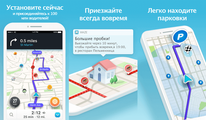
Waze is owned by Google, but not affiliated with Google Maps. This is not just a navigation application, but a community of drivers who help each other by informing about the situation on the road. You can attach a photo and a text note to each message. You will receive information about gas stations (including gasoline prices), campgrounds, catering establishments, traffic police posts, traffic jams and accidents along the entire route.
Once you've chosen a destination, Waze will suggest several route options and remember them after you've driven them several times. In the "Scheduled Trips" option, you just need to enter the time and date of arrival at a specific location, after which Waze will tell you when it is best to leave. Nice little things: you can send the estimated time of arrival by email, text message in the application itself or via WhatsApp. By adding friends to the application, you can see where they are at the moment. A very handy application, especially for city driving. In rural areas, it is much less useful.
The Waze developers have focused on informing users about the traffic situation. Different icons indicate the location of accidents, road closures, security cameras and traffic police patrols. Traffic jams are shown with red lines. The app can automatically plot alternative routes. All additional information comes from Google and Foursquare.
Available for Android and iPhone .
OsmAnd
OsmAnd is fundamentally different from most of the other apps on our list. This service is designed for people who need to use maps offline. You can download a huge number of maps, and most of them have a very high level of detail.
However, the free version has some restrictions on the number of downloads. To download more maps, you need to purchase the paid version. This can be done in the application itself. The functions of the application include: turn-by-turn navigation, offline search, maps for different types of transport.
The data of the OpenStreetMap service is used, supplemented with its own graphical interface and functionality. Information about attractions is taken from Wikipedia. Well thought out navigation for drivers, cyclists, motorcyclists and pedestrians. Plotting alternative routes on the fly is useful, for example, if you missed a turn. Display settings are quite flexible, there is a choice of day and night themes.
Available for Android and iPhone .
CoPilot
The CoPilot GPS app comes in handy if, for example, you are abroad and do not want to pay roaming charges. You only need to download the maps you want. It is advisable to do this through a high-speed connection, since they "weigh" a lot. Once you've done that, you can use offline turn-by-turn navigation, plan routes, and use Google search for place names or addresses.
If you miss a turn, the app will quickly create a new route based on your current location. It also monitors your vehicle's speed and warns of road restrictions, shows traffic safety cameras and provides other useful information.
The app creates routes perfectly: at least three options are issued for each trip. The maps are highly detailed. CoPilot has information on thousands of hotels, restaurants, ATM machines and points of interest.
The cost of the application is $ 10 in the US and $ 45 in Europe. The app is more for drivers, so there is no point in paying pedestrians for CoPilot GPS. The fully functional trial version can be used for seven days. The functionality includes support for three-dimensional maps and a voice assistant . Once the trial period ends, 3D support and turn-by-turn navigation rendering are disabled.
Available for Android and iPhone .
HERE WeGo
HERE shows information about transport traffic in real time and allows you to download transit maps with public access, saves various places in the smartphone's memory for subsequent routing. Using the built-in constructor, you can modify old maps and draw your own maps.
You can download maps for offline use in areas where access to the Web is difficult or completely absent. There are offline maps for 100+ countries and 1,300+ cities in the world, including most of the settlements in Europe and North America. They contain ready-made routes, ticket prices, car rental prices and train / bus timetables. All this is free!
Here WeGo is suitable for drivers, pedestrians, cyclists, motorcyclists, public transport passengers. The app will find the fastest route for any type of travel. HERE will even take into account the unevenness of the terrain and tell you whether you need to climb or descend more on your trip or hiking. As with Google Maps, you can order a taxi here or find the nearest car rental location. The service will also calculate the full cost of the trip by public transport even before it starts.
It is possible to share data about your location. The functions of laying bicycle routes are very convenient, there is a database of public transport routes, a large database of attractions. Information sourced from Wikipedia, TripAdvisor, BlaBlaCar, Expedia, Car2go and GetYourGuide.
Available for Android and iPhone .
MapFactor
MapFactor is a fairly popular navigation app with basic navigation and GPS functionality. The service uses the API of the OpenStreetMap mapping project, which allows you to download and update maps for free to work with them offline.
At the same time, it is possible to use data from the Dutch developer TomTom instead of OSM. True, to do this, you have to pay a little. Some features are also paid. For example, projection of navigation onto the windshield of a car or selection of the optimal route.
MapFactor has more than two hundred maps, including 56 countries in Europe and 53 states in the Americas. At the first launch, the application will offer to download maps for offline use, since online maps are not included in the basic functionality, which includes: voice commands, cross-border routing (no need to switch between countries), 3D mode, day and night themes.
Available for Android and iPhone .
Citymapper
The Citymapper database contains information about cities around the world. It includes train and bus timetables, walking routes, and real-time traffic intensity.
The latter is especially useful if you live in the suburbs of a metropolis, but regularly need to get to and from the center. The application will compose the desired route, taking into account the traffic intensity and traffic jams, which will allow you to spend less time on the road. Citymapper may not be that good if you live in the middle of nowhere, but nothing better has been invented yet. The latest update introduces a new walking mode with instant ETA and turn-by-turn navigation. And also the turn-by-turn navigation for cyclists and scooters has been improved.
If you often travel outside the city or live in the countryside, there are better options than Citymapper. But in a large settlement it is an indispensable assistant: it will show the approximate cost of a Uber ride to your destination, the routes of all types of public transport, give information about the arrival and departure times of the next train or bus, and possible delays on the road.
Available for Android and iPhone .
Scout
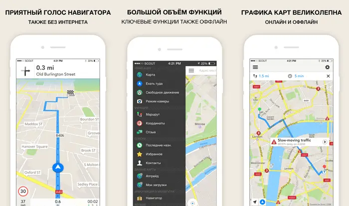
The Scout GPS app was formerly called TeleNav. Having changed the name, logo and graphical interface, it remains reliable and stable, including all the necessary functions.
True, the Scout GPS focuses more on people than on navigation, which sets it apart from its peers. Scout GPS can automatically inform relatives of your expected arrival time, send notifications when other users need you. Now, to tell other users where you are or where you are going, you do not need to leave the application to open WhatsApp. By the way, many car manufacturers install Scout GPS Navigation by default.
This navigator is also interesting because it offers integration with social networks, chat support and other useful features. Maps are downloaded from the OpenStreetMap server. Information about traffic intensity, sights and parking is provided.
Available for Android and iPhone .
MapQuest
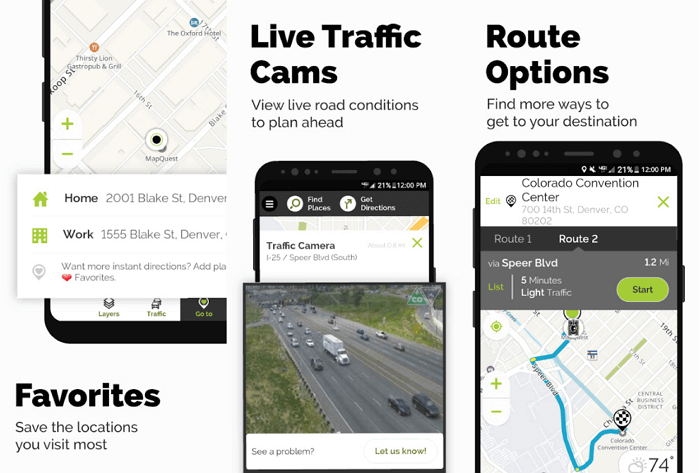
Many people remember MapQuest from the old days and think that this platform was completely absorbed by the Google Maps service. However, MapQuest for Android is still downloaded by millions of users. There are reasons for this: a high degree of detail, a large database of interesting places, turn-by-turn navigation, the ability to share the expected arrival time at your destination with friends.
MapQuest has real-time information on traffic intensity (where possible), re-routing in case of traffic jams along the way, a service for finding refueling stations with the cheapest fuel. You can even call a tow truck directly from the application itself if the car breaks down.
MapQuest uses Apple Maps and Google Maps, supplementing them with the coordinates of the nearest catering establishments, gas stations, hotels and shops. MapQuest provides both road and walking routes. Information from live cameras is updated in real time, which means that you can familiarize yourself with the situation on the road even before the start of the trip. MapQuest even lists speed limits for different sections of the road.
Available for Android and iPhone .
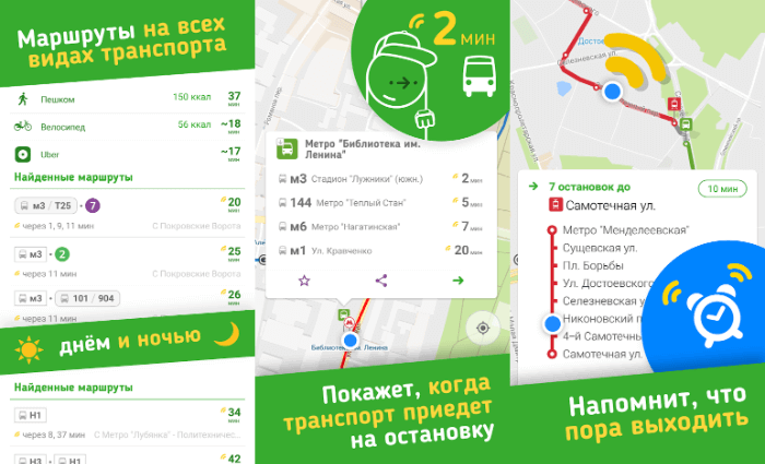
Google maps
You can find a bar or restaurant in Google Maps, and the app will show you several directions from where you are. Nearby will show user ratings for restaurants, bars and entertainment venues, as well as how long it will take to reach them on foot and by car.
The turn-by-turn navigation is well developed, and the search uses an intelligent algorithm that takes into account previous trips. While you are on the road, the app constantly checks for alternative routes and from time to time suggests adjusting the route so you can get to your destination faster.
If you need offline navigation, you can download maps for offline mode. Voice navigation is also available. After thirty days, the cards are automatically deleted, so they need to be updated regularly.
To download the map, go to the menu in the form of three horizontal lines in the upper left corner of the screen, select "Offline". The application will automatically recommend the maps you need, taking into account your address and places where you often visit.
Available for Android and iPhone .
Polaris
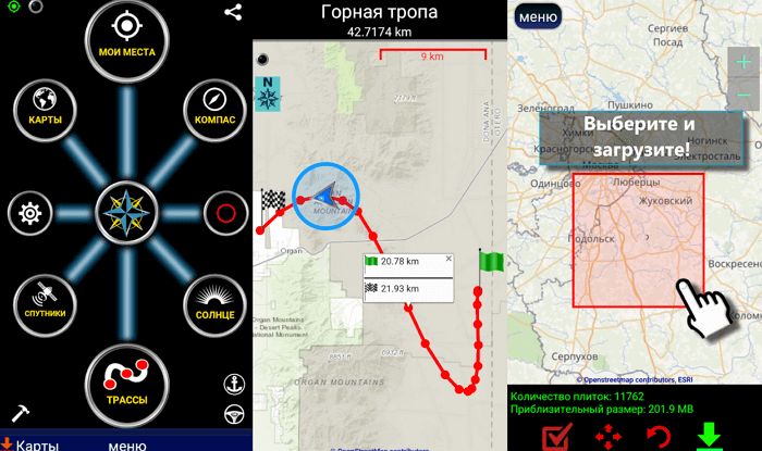
The Polaris Navigation developers tried to create an all-in-one navigation application. They managed to do it! It's especially worth noting that the app draws information from many different sources, including Google Maps, OpenStreetMap, MapQuest, and Cycle Route Maps. The user can independently choose the source of data acquisition.
Polaris Navigation offers different coordinate presentation formats, route recording options, a unique routing system, voice navigation, useful features for hiking, camping, fishing, hunting and other outdoor activities. The interface seems a bit outdated, but it doesn't affect the application's performance.
Available for Android only .
Komoot
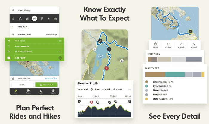
Komoot topographic maps are designed for hikers and cyclists: the difficulty of passing a particular route is indicated. The database is compiled from information from open sources and from the users themselves.
Maps work offline , without Internet access. The application takes into account factors such as the difficulty of the route, the relief, ascents and descents, distances. As you follow, Komoot shows how much distance you have already covered or traveled and how much is still left.
The first card can be downloaded for free, while the rest will have to be paid for. The average cost of a card is approximately $ 4. A set of all cards will cost $ 30. It includes most regions of Europe and North America, as well as some countries in Asia. Updates are free.
Komoot is not designed for drivers, it is designed exclusively for hikers and bikers in nature. You can create your own routes using the built-in planner and use the maps offline. You can also save data about your travels and share information with your friends.
Available for Android and iPhone .
inRoute
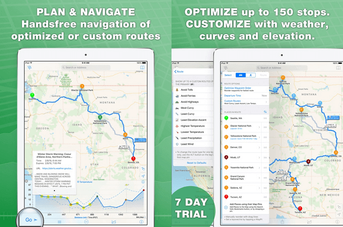
When it comes to multi-stop travel, there is nothing better than inRoute. In the free version, the number of stops per route is limited to five. Information about sharp turns, ascents and descents is given. By searching, you can find the nearest gas stations, food outlets.
inRoute will plan when to go based on real-time weather information. You will have to pay $ 15 to upgrade to the premium version, which provides up to 25 stops per route. If you need up to a hundred stops, you need to purchase the $ 30 version.
Available for iPhone only .